Why We Need Arabic Language Models
24 August 2025
Published online 15 April 2019
Declassified U2 spy photos reveal unseen Middle Eastern archaeological features.
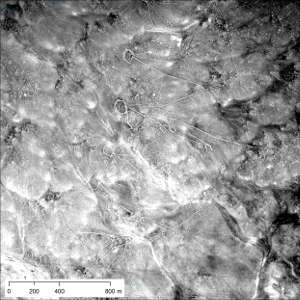
University of Pennsylvania/Emily Hammer
At the peak of the Cold War, American U2 spy planes carried out reconnaissance flights over Europe, the Middle East, and central eastern Asia, taking images of potential military targets. Photos from 11 of the missions were declassified decades ago, but they weren’t indexed, and a guide to the flight paths and areas photographed was not available, making it challenging for archaeologists to use them. Now, Emily Hammer of the University of Pennsylvania and Jason Ur of Harvard University have developed a systematic index of the U2 films and documented how they digitized the negatives. Their work is providing insights into archaeological features that can no longer be seen, in countries such as Jordan and Iraq.
Hammer and Ur cross-referenced the film cans held by the National Archives and Records Administration with declassified documents in the CIA Records Search Tool to identify the films belonging to each mission. Next, they combined images taken by the low-resolution tracking camera on each flight with modern satellite imagery available in Google Earth and other programs to reconstruct the flight paths of the declassified missions. This enabled them to select negatives covering sites of interest, which they then photographed and processed to produce high resolution photos of specific archaeological features.
“Archaeology in many ways is a race against time. Humans are continually transforming the Earth’s surface, partially or fully erasing traces of the past,” says Hammer. “Old aerial and satellite images allow archaeologists to travel back in time to the mid-twentieth century, before urban expansion, modernization, development, and agricultural intensification wiped away surface traces of these ancient communities, which had previously survived in many cases for thousands of years.”
U2 photos from Jordan provided the best view to date of stone enclosures known as desert kites, which are believed to have been mass hunting traps for gazelles and other animals 5,000 to 8,000 years ago. Desert kites need to be studied from an aerial perspective, but many of their features have been destroyed since the 1960s and so have only been seen in lower resolution images from the CORONA spy satellite program, which ran between 1959 and 1972.
Hammer and Ur also discovered new features of the canal system that supported the Assyrian capital Nimrud, in the north of modern-day Iraq, such as vertical shafts used for construction and maintenance, which hadn’t been identified in the CORONA images.
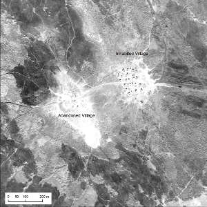
University of Pennsylvania/Emily Hammer
“It’s always exciting to gain access to a new imagery archive,” says Jennifer Pournelle, an archaeologist at the University of South Carolina who has experience with aerial and satellite archaeology. “How much impact it will have depends on what specific questions you want to ask.”
According to Pournelle, who wasn’t involved in the study, the value of aerial or satellite images in archaeology depends on how early the coverage started, its continuity over different seasons and several years, and how much imagery is available from before industrial development, which often obscures interesting features.
U2 photos offer a promising resource based on these criteria.
To help others use them, Hammer and Ur provided detailed information on how they photographed the films and reconstructed the images, as well as an explanation of the U2 camera system and how to interpret the negatives. More importantly, they created online, open access geospatial indexes of the declassified missions so researchers can easily identify which films they need. These resources will make it easier for scholars to use the U2 photo archive, offering them unprecedented views into history.
doi:10.1038/nmiddleeast.2019.55
Hammer, E & Ur, J. Near Eastern landscapes and declassified U2 aerial imagery. Advances in Archaeological Practice http://dx.doi.org/10.1017/aap.2018.38 (2019).
24 August 2025
21 August 2025
18 August 2025
30 August 2017
21 December 2016
29 January 2019
Sign-up to receive our e-alert update every two weeks to keep up with everything new on the portal.
Sign up for e-alerts
Stay connected: