The Missing Kingdom: Why Fungi Must Be Central to Conservation Strategy
28 December 2025
Published online 23 February 2022
Atmospheric rivers carry huge volumes of water from low to higher latitudes. The impacts of these ‘rivers in the sky’ on the coastal regions have been studied extensively, but little is known about how they affect land far from the oceans, such as in the Middle East. Amin Dezfuli, a hydrometeorologist at NASA’s Goddard Space Flight Center, explains what we currently know and why it is important we learn more.

Precipitation is a key element affecting various types of extreme events, so it is crucial to know why, where, when and how much it rains in the region. The answers require a full understanding of the complex interaction between several climate features that act across spatial and temporal scales. Each phenomenon—for example mid-latitude weather systems or the summer Indian Monsoon—may be active in a specific season. Geographical features, like the Zagros mountains in Iran, northern Iraq and southeastern Turkey, also play a major role in regional weather phenomena, such as the Shamal winds and the Zagros Barrier Jet (ZBJ). Atmospheric rivers are a meteorological phenomenon that contribute to regional rainfall. They are long, narrow bands of concentrated atmospheric water vapour, like rivers in the sky, that transport large amounts of moisture from tropical and extratropical sources to land3.
Atmospheric rivers are a crucial component of the hydrometeorological system that affects water resources and floods in the coastal regions of the eastern Pacific and Atlantic oceans. They contribute up to 50% of annual precipitation and account for nearly 85% of insured flood losses in the western United States3,4 . While the impacts of atmospheric rivers on coastal regions of North America and Europe have been extensively studied, much less is known about their characteristics and contribution to flooding in the Middle East. That limited research has shown that around 13 to 30 atmospheric rivers occur in MENA annually, and these are most common in April over the Fertile Crescent 5,6.
Documenting impacts
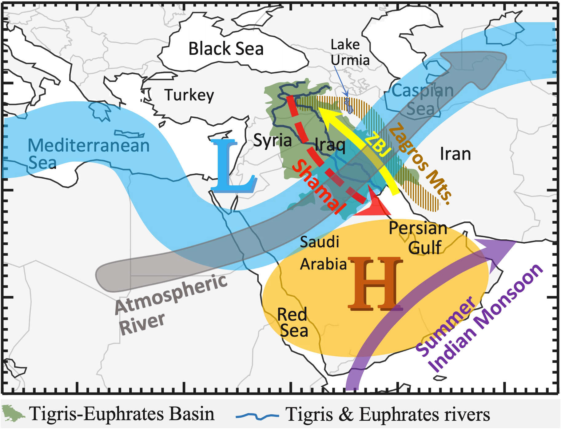
Adapted from Dezfuli et al. (2017)15 © American Meteorological Society, used with permission) and Dezfuli et al. (2021, Copyright American Geophysical Union) with modification.
Enlarge image
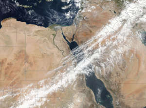
The devastating floods of April 2017 in northwestern Iran were also attributed to an atmospheric river that caused torrential rainfall and rapid snowmelt over highlands. Despite its adverse impacts, the ‘sky river’ brought much-needed water for restoration of the desiccating Lake Urmia—one of the world’s largest hypersaline lakes. The 2017 event highlighted a unique characteristic of atmospheric rivers in the Middle East: they can facilitate the transport of mineral dust aerosols along their dominant pathways. These aerosols can impact air quality and cloud formation.
Another distinct feature of atmospheric rivers in the region is their ability to travel long distances over hot and dry deserts while retaining their moisture, which is primarily derived from regional sources such as the Mediterranean and Red Seas. Unlike the 2019 event, seasonal rainfall in 2017 was moderately below average, underlining the fact that heavy floods can happen in both wet and dry years.
Like many other weather phenomena, skilful deterministic forecasting of atmospheric rivers is limited to a one-week lead time9. Projections for the coming decades are much more uncertain. Generally, climate model simulations for the end of the 21st century show that, due to global warming, atmospheric rivers might contain more moisture. However, the projected changes in their frequency, intensity, spatial variability and associated precipitation may vary markedly by model and region10. The limited research over the Middle East has suggested an increase in frequency of atmospheric rivers in the northern part of the region, though overall precipitation is projected to decrease11.
Future research and decision support
The scope of our knowledge about the impact of atmospheric rivers on floods in the Middle East is limited to a few case studies, mainly focused on western Iran. To fill this void, these studies can be used as a guideline for similar analyses to investigate whether floods in countries such as Iraq, Syria and Kuwait can also be attributed to this phenomenon. The dust component of the atmospheric rivers, as shown in 20178, may have relevance to air pollution in several countries across the region, including Egypt, Saudi Arabia, Iraq, Jordan, Syria, Kuwait and Iran. It is hoped that the findings of that study8 will motivate a comprehensive analysis of ‘dusty atmospheric rivers’ in the region.
NASA Worldview
For sub-seasonal predictions, future research might focus on developing empirical models and hybrid dynamical-statistical approaches. These models can be designed in the context of forecasts of opportunity; that is, prediction skills might be better than normal when atmospheric rivers occur due to the presence of specific phases of some large-scale climate phenomena. The added value of this approach has been shown for atmospheric river prediction along the west coast of North America, incorporating the Madden–Julian Oscillation, El Niño-Southern Oscillation, and Quasi-biennial Oscillation, which are major sources of global predictability on the sub-seasonal timescale12,13.
For long-term planning, more research is needed on the future projection of atmospheric river characteristics in the region, using simulations from the Coupled Model Intercomparison Project Phase 6 (CMIP6)14. That effort may include assessment of changes in frequency, intensity, contribution to precipitation, spatial patterns and interannual variability of atmospheric rivers in the Middle East. Such analysis might have large intrinsic uncertainties but would be helpful as a broad guideline to design strategies for managing hydrological extremes in the coming decades.
In short, operational forecasts of atmospheric rivers should be included in decision support systems for better management of floods and water resources in the Middle East. These predictions may have public health implications as we learn more about the characteristics of dusty atmospheric rivers in the region.
Amin Dezfuli (@AminDezfuli) is a senior research scientist working at the NASA Goddard Space Flight Center through Science Systems and Applications, Inc. (SSAI). His research focuses on climate change and extreme events, their causes and impacts, mainly over the Middle East and Africa. He uses in situ and satellite-based observations as well as climate models to address questions of fundamental and applied climatology and water resources. He has a PhD in atmospheric sciences from Florida State University.
This commentary was supported by the Global Modeling and Assimilation Office (GMAO) core funding, provided under NASA’s Modeling, Analysis and Prediction (MAP) program.
doi:10.1038/nmiddleeast.2022.8
28 December 2025
24 December 2025
24 December 2025
07 December 2021
26 August 2021
04 November 2021
Sign-up to receive our e-alert update every two weeks to keep up with everything new on the portal.
Sign up for e-alerts
Stay connected: