The Missing Kingdom: Why Fungi Must Be Central to Conservation Strategy
28 December 2025
Published online 5 February 2021
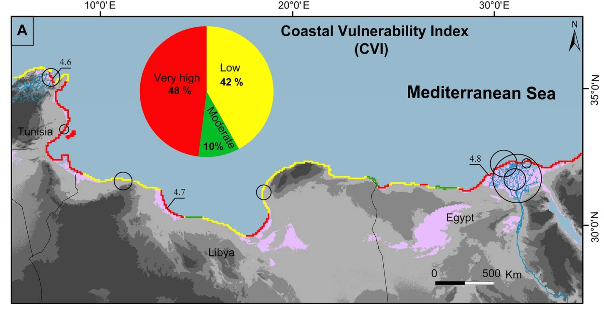
Heavily inhabited areas close to sandy beaches and river deltas in Tunisia and Egypt are highly vulnerable to shoreline retreat and coastal flooding.
Scientific Reports vol. 11, Art. No.: 2320 (2021)
Enlarge image
An international team, including researchers at the University of Tunis El Manar and the University of Carthage in Tunisia, combined satellite data, aerial images, and geologic and topographic maps with regional socioeconomic records to assess coastal vulnerability in the southern Mediterranean Basin, an area that includes the coasts of Tunisia, Libya and northern Egypt.
They used the data to compile a Coastal Vulnerability Index (CVI) based on seven geological and physical parameters, a Socioeconomic Vulnerability Index (SVI) derived from economic factors, and an Integrated Coastal Vulnerability Index (ICVI) that highlights areas of concern.
The investigations showed that almost half of the entire Mediterranean coast from Tunisia to Egypt had high to very high vulnerability risk scores. The highest areas of vulnerability were located in the Gulf of Tunis and the Nile Delta.
The researchers’ assessments suggest a correlation between high areas of shoreline vulnerability and anthropogenic drivers, such as the existence of dams and high urban density. Dams and other obstructions block the flow of sediment to the coastline, while urbanization leads to resource over-exploitation and deterioration. These and other factors lead to shoreline retreat, coastal flooding, and seawater intrusion into coastal aquifers, affecting crop production and compromising food security.
The evolution of these vulnerability maps will be crucial for improving policies and land governance in coastal areas, the researchers say. “Urgent urban policy updates are required to remedy the current situation, which will only be aggravated if left over time,” says the study’s lead author Essam Heggy of the University of Southern California, US.
“Coastal degradation on the southern shores of the Mediterranean is a known but poorly quantified phenomenon,” says geographer and ecologist, Wolfgang Cramer, of Aix Marseille Université in France, who was not involved in this study. “This study fills an important gap in the assessments of coastal risks. Most observations and model studies are performed in the North of the Mediterranean, giving the misleading impression that threats may be less relevant in the south and east of the basin.”
The researchers next aim to study the sandy beaches of the Eastern Arabian Peninsula in the Arabian Gulf, which have undergone some of the fastest changes in the world.
doi:10.1038/nmiddleeast.2021.10
Hzami, A. et al. Alarming coastal vulnerability of the deltaic and sandy beaches of North Africa. Sci. Rep. https://doi.org/10.1038/s41598-020-77926-x (2021).
28 December 2025
24 December 2025
24 December 2025
22 October 2018
09 September 2019
20 February 2019
Sign-up to receive our e-alert update every two weeks to keep up with everything new on the portal.
Sign up for e-alerts
Stay connected: