Research Abstract
恐れの風景が宇宙から見える
Landscape of fear visible from space
2011年6月14日 Scientific Reports 1 : 14 doi: 10.1038/srep00014
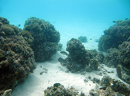
一般に公開されているGoogle Earth(グーグルアース)の衛星画像に生態学的理論を結びつけることにより、捕食者と被食者の行動的相互作用が生み出す景観規模の形状を、離れたところから観察することができる。ヘロン島(オーストラリア・グレートバリアリーフ)の礁湖の環境をGoogle Earthの画像で調べたところ、離礁を取り巻く藻場に明瞭な輪状パターンが現れた。地上調査の結果、予測されたとおり、礁縁から離れるにしたがって藻類の林冠が高くなっていることが確認された。さらに、喫食分析により、草食動物による喫食がこのパターンを形成していることが示された。この知見を近年の行動生態学的研究の成果と組み合わせることにより、捕食者に対して草食動物がとる集合的行動パターンは、宇宙から明瞭に確認することができる規模の植生分布を形成する場合があることが明らかになった。特定の場所のGoogle Earth画像を経時的に連続して利用すれば、この技術により、地球上のほぼすべての場所に関して、捕食者の除去(漁業や狩猟など)や回復および再導入(海洋または陸上の保護区など)の連鎖的で間接的な影響が、低コストで迅速に遠隔監視されるようになる可能性がある。
- シドニー工科大学(オーストラリア)
- マッコーリー大学(オーストラリア)
By linking ecological theory with freely-available Google Earth satellite imagery, landscape-scale footprints of behavioural interactions between predators and prey can be observed remotely. A Google Earth image survey of the lagoon habitat at Heron Island within Australia’s Great Barrier Reef revealed distinct halo patterns within algal beds surrounding patch reefs. Ground truth surveys confirmed that, as predicted, algal canopy height increases with distance from reef edges. A grazing assay subsequently demonstrated that herbivore grazing was responsible for this pattern. In conjunction with recent behavioural ecology studies, these findings demonstrate that herbivores’ collective antipredator behavioural patterns can shape vegetation distributions on a scale clearly visible from space. By using sequential Google Earth images of specific locations over time, this technique could potentially allow rapid, inexpensive remote monitoring of cascading, indirect effects of predator removals (e.g., fishing; hunting) and/or recovery and reintroductions (e.g., marine or terrestrial reserves) nearly anywhere on earth.