River subbasins more depleted than
official figures show
09 April 2024
Published online 13 December 2012
NASA scientist Essam Heggy is turning radar sounding technology developed to search for water on Mars towards Earth in an effort to map desert groundwater and monitor the changes that climate change can have on them.
"There is an urgent need for large-scale surface and subsurface measurements similar to those being carried out in the Arctic and Antarctic using sounding radars and other techniques," says Heggy.
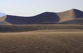
In 2011 Heggy, who is based at NASA's Jet Propulsion Laboratory (JPL) in Pasadena, California, led an international team to probe Kuwait's desert for freshwater aquifers using a sounding radar – a low frequency, radar detection system that can penetrate deep into a planet's surface.
With a 40MHz, low-frequency sounding radar strapped to a helicopter, Heggy scanned the subterranean desert at depths of up to 65 metres. They found two fossil aquifers and charteded their various inflows and outflows. The team then produced the highest resolution maps yet of any groundwater system.
And Heggy is now preparing for his next mission, this time to cover more of the region's aquifer system. His team also plans to develop an 'orbital mission' concept that will attempt to explore and monitor aquifers underneath the Earth's driest deserts in the North African Sahara and the Persian Gulf.
"If successful, this will allow us to understand the dynamics of aquifers at a high resolution and large scale and will revolutionize the way we understand these fossil water bodies," says Heggy. By mapping the groundwater dynamics in the region, he hopes we can better understand how global climatic variations affect hyper-arid regions, which make up to 10% of Earth's surface.
Heggy also works on several planetary radar projects that aim to explore Mars, the Moon, comets, asteroids and the solar system's icy moons. "There is a lot we can learn from comparative planetology about these phenomena," explains Heggy.
The research in Kuwait builds on previous work that began in 1999 in Egypt's western desert. During the early 1980's, JPL used the Space Shuttle Synthetic Aperture Radar to map shallow drainage networks that suggest the Sahara had plentiful water activity on its surface thousands of years ago.
We cannot resolve a problem that we do not understand.
This type of collaborative research with Arab states does not often come easy, however.
"The problem mostly arises from the wrong perceptions on the value of the partnership, unrealistic expectations, and the availability of the resources to perform the science," says Heggy. However, he notes that these challenges can often occur from both collaborators, not just between Arab states.
"While it's impressive to see that water exploration on Mars is a highly reputed endeavor, today water characterization of Earth's hyper-arid regions remains a charity programme that is done on the sidelines of scientific and technological progress," says Heggy, although he hopes his team's work can address this deficit by adapting cutting-edge technologies to explore one of the last frontiers on the planet.
He believes that understanding the characteristics of these aquifers will prove central to adapting to the effects of climate change in the region. "We cannot resolve a problem that we do not understand, and that is why I think the community had limited success in addressing droughts in Africa in past decades."
doi:10.1038/nmiddleeast.2012.177
River subbasins more depleted than official figures show
09 April 2024
Arab countries perform poorly on climate action scorecard
24 March 2024
12 March 2024
Sign-up to receive our e-alert update every two weeks to keep up with everything new on the portal.
Sign up for e-alerts
Stay connected: